
Another day in Aubrac majesty
DIDIER HEUMANN, MILENA DALLA PIAZZA, ANDREAS PAPASAVVAS

We divided the course into several sections to make it easier to see. For each section, the maps show the course, the slopes found on the course, and the state of the roads. The courses were drawn on the « Wikilocs » platform. Today, it is no longer necessary to walk around with detailed maps in your pocket or bag. If you have a mobile phone or tablet, you can easily follow routes live.
For this stage, here is the link:
https://fr.wikiloc.com/itineraires-randonnee/de-nasbinals-a-st-chely-daubrac-par-le-gr65-29858610
It is obviously not the case for all pilgrims to be comfortable with reading GPS and routes on a laptop, and there are still many places in France without an Internet connection. Therefore, you can find a book on Amazon that deals with this course. Click on the book title to open Amazon.
 |
The Camino de Santiago in France / V. From Puy-en-Velay to Cahors (Via Podiensis) on GR65 track |
If you only want to consult lodging of the stage, go directly to the bottom of the page.
Aubrac is an absolute strangeness, grandiose and severe. The immense loneliness, the absence of landmarks make of this country a non-tourist place, one of those magic places which nurse our imagination. It is a country almost unreal, a country of which you do not know precisely what its magic is made of. It is a vast plateau of schists and granites, covered here and there with basalt flows, a large ellipse 55 km long and 40 km wide, linked to the mountains of Margeride, surrounded by the often-tumultuous waters of the Truyère River and the quieter waters of the Lot River. The route heads always southwest in the bare steppe, until Aubrac village, where it leaves definitely the plateau. Today, you’ll be walking in Lozère department, almost to Aubrac village, then in Aveyron department on the downhill slopes of Aubrac Mounts.
Still another day to gaze at images of an almost barren country in gentle slopes, meadows, covered in spring of thousands of wild flowers in the plains, where other thousands of brown cows graze quietly. The air is pure and there are no trees to catch the eye or the blowing winds. Sometimes small forest patches appear amid endless pastures. Aubrac is a country for cattle, and men are almost absent. Aubrac is a bit like the Argentinean pampa, a “desert of herbs ” as it has often been called. Here, nothing or so little thing breaks monotony and uniformity. These vast solitudes, where the pilgrim walks for hours, perceiving in the distance only a rare tree or a frail bush, were formerly covered with vast forests. Only modest remnants remain. These high woods, forever disappeared, belonged to the hospital of Aubrac, who also managed the forests located above Aubrac and those below, to St Chély d’Aubrac, forests still present nowadays.
In the rounded hills, the moor sometimes replaces the pasture. Many blocks of granite are placed here and there, memories of a period when glaciers left traces of their passage. Aubrac means “Alto braco” (high plain). The same landscapes of pastures succeed one another, the hamlets are further spaced. The landscape is strewn with old “burons”, huts of solid volcanic stone, with sloping roofs, where, long ago, shepherds lived there to make cheese and protect themselves from the strong winds that blow here. In this ocean of greenery, the whims of the winds can become terrible, without a mountain curtain to curb their momentum. One of these winds is “Lo Biso”, the terrible kiss that comes from the North. Another is “Lo Traverso”, another northern wind that brings clouds. “Olto” (also called “The Autan”) comes from the South, a dry and violent wind. Sometimes another dry and hot wind, “Lo Souledre”, blows so violently.
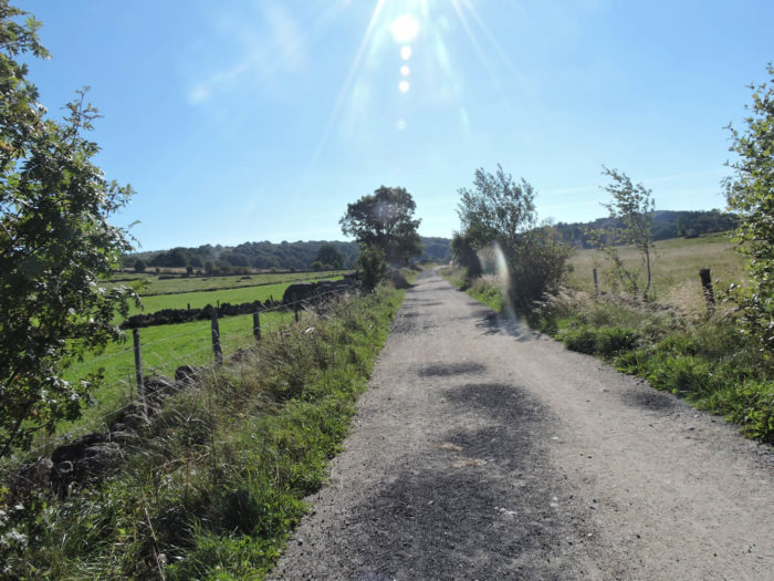
Difficulty of the course: Slope variations (+276 meters/-642 meters) are not too elevated today, yet the stage is rather tough. In the beginning of the stage, you’ll be climbing up, sometimes with efforts, to the top of an undulating plateau to reach 1324 meters. You’ll be walking on “drailles” (cattle pathways) in very large pastures, amidst stone walls and barbed wire. The country belongs to cows and pilgrims. It is just fascinating. Sometimes small brooks appear here and there. Beyond Aubrac village, when the route leaves the plateau, the downhill slope is rather steep to reach, on highly stony paths, St Chely d’Aubrac. This descent can be a little « terrible » in bad weather. In these conditions, take the road that goes down to Chély-d’Aubrac.

Here is a stage almost exclusively on dirt roads, which is quite rare on St James’ track:
- Paved roads: 2.9 km
- Dirt roads: 13.3 km
Sometimes, for reasons of logistics or housing possibilities, these stages mix routes operated on different days, having passed several times on Via Podiensis. From then on, the skies, the rain, or the seasons can vary. But, generally this is not the case, and in fact this does not change the description of the course.
It is very difficult to specify with certainty the incline of the slopes, whatever the system you use.
For « real slopes », reread the mileage manual on the home page.

Section 1: On your way to the great « drailles ».

General overview of the difficulties of the route: a constant climb towards Aubrac Pass, but, with rare exceptions, the slope is very reasonable.

|
The GR65 crosses Nasbinals and follows the departmental road towards the Aubrac Pass. |
|
 |
 |
|
Very quickly, it leaves the departmental road at the level of the neighboring hamlet of Le Coustat. Beyond the hamlet, it then climbs slowly, first on the tar, then on a rather stony lane, through the hardwoods. The pines have disappeared and the oak most often replaces the conifers. Beeches and oaks sometimes make like real little tunnels of shade. |
|
 |
 |
| But quickly, the landscape opens up and hedges replace forests. However, the change in vegetation sometimes gives the feeling of having left Aubrac area. The pines are no longer present, there are even ash trees here and there, but the cows still graze behind the granite walls capped with barbed wire. | |
 |
 |
 |
 |
| The pathway passes near a cross planted in the granite walls, climbs gently into the pastures below the dense Aubrac forests. The ground is gray, the soil gravelly. Everything has become darker, even the granites on the walls. | |
 |
 |
| It’s a bit as if we had been changed Aubrac from the day before. There are significantly more trees. Did the monks knowingly avoid clearing the area? | |
 |
 |
| Soon, the pathway finds the brook known as Pascalet, at Pascalet Bridge. This stream has more branches than it has water. | |
 |
 |
|
You’ll continue to climb slowly on the hill, on a very stony pathway, in the middle of the bushes. |
 |
The pathway gradually approaches the huge Pascalet/Ginestouse farm. Gigantic, to say the least. You can see the pastures stretching endlessly to the edge of the forest above where you will of course have to climb.

| The route winds through a never-ordinary landscape, shaped by geography, history and people. Agriculture and in particular livestock still mark the history of this landscape very deeply. Cattle everywhere graze on scarce grass. From May to October, young cows, bulls and calves spend the summer here and descend further down, between October and April. The cattle roam, without shepherds, in the meadows and the moor fenced with barbed wire.
In the Aubrac breed, the muzzle, the edges of the eyelids and the eyelashes are surrounded by a white halo, as if the cattle had been made up. These elegant cows, with a tawny coat, sport beautiful horns. Bulls are almost always paler than cows. They took off their beautiful horns. Today, livestock on Aubrac plateau are primarily used for meat production. This breed is peaceful, although sometimes a few troublemakers deserve special treatment. Here, a double protective barrier, electrified, does not invite the walker to exceed the barrier in order to be able to ogle the bull. |
|
 |
 |
|
The track then enters a huge farm which apparently covers the entire hill. The area seems complex, with many buildings, farms and “burons” scattered all over the place. |
|
 |
 |
And the cows watch you go by with their usual placidity, with their large velvet eyes. “Pilgrim, go your way” they seem to say with kindness.

Section2: Walking on the great « drailles ».
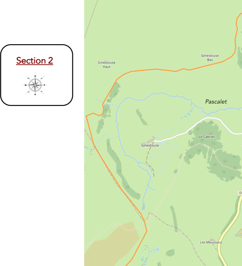
General overview of the difficulties of the route: a constant climb towards the Aubrac Pass, but, with rare exceptions, the slope is very reasonable.

Below the pathway is the main body of a large farm.

| It is here that the first large “drailles” appear, these half-grassy, half-stony tracks, drawn near the stone walls to move the cattle. Shortly after, a barrier blocks the way. These are metal barriers that the peasants move around as needed. | |
 |
 |
| The space is so vast that the gaze of the walker cannot guess how far his steps will take him. Below the “draille”, there is another body of buildings further on. There is probably more than one owner here. | |
 |
 |
| These “drailles” do not have an organized structure. Did men create them or are they just the result of the repeated trampling of cattle that have passed through here over the centuries? | |
 |
 |
| You not find here the Aubrac organization before Nasbinals. The pastures are not fragmented, surrounded by stone walls and impassable barbed wire. There is only an electric barrier to limit the pathway. | |
 |
 |
| Another barrier, near a “buron”, and the country opens up even more, always wider. The pathway continues to sink into the middle of large “drailles”, sometimes crossing small boulders torn under the claws of the frost of harsh winters. | |
 |
 |
Up there, above our heads, a “buron” seems to be placed on the roof of the world.

| A major event in Aubrac is transhumance. Around St Urbain Day (May 25), the cattle are decorated with feathers, pompons, ribbons and flowers, and driven to the highlands to spend the summer. The cattle remain here until the feast of St Guiral on October 13th. Originally, the “buroniers” spent here the summer period. What was initially a simple hut soon turned into something more solid, the “buron”, with its slate roof. The “buron” was also a place to make and maturate the cheese. The work was run by the “cantalès”, the cheese maker. The “bedelie” looked after the animals, finding the best pastures. The “pastre” was in charge of milking twice a day. There was still a “rol”, a young boy doing everything.
At the end of the XIXth century, 1,200 “buronniers”, occupying 300 “burons”, produced 700 tons of cheese, a quantity requiring the presence of at least 15,000 dairy cows on the plateau. From 1930, production began to decrease substantially and the number of active “burons” fell rapidly and dramatically. In 1950, annual production fell to 25 tons. It was becoming difficult to find staff wanting to spend the summer away from comfort. As a result, the price of cheese produced here became prohibitive. But there! There is also another reason. Aubrac cows, with their Andalusian eyes, are poor dairy cows. The annual production of a selected Aubrac cow is 1’550-2’000 litres per year, far from the potential of a good dairy cow, which is in the order of 10’000 litres. Thus, gradually, the choice was on dairy breeds, Holstein (Friesian, Prim’Holstein, origin: Holland, Germany) and Simmental (origin: Switzerland). Today, 90% of the milk produced to produce Laguiole (AOC Aubrac cheese) comes from the Simmental breed. Since 2004, a new regulation excludes cows other than Aubrac and Simmental for the development of Laguiole cheese. These dairy breeds are rarely present on Aubrac plateau. Be that as it may, the Aubrac breed always has its fans. There is a strong feeling for a return of the original race in the country. Despite the fact that “burons” have become a tourist attraction today, the fact remains that more than 150,000 Aubrac cattle still roam the country.
|

| And it is in the midst of the Aubrac cows that the severity of the “drailles” subsides for a moment near a grove. | |
 |
 |
 |
 |
| On leaving the woods, here are these magnificent “drailles” again. | |
 |
 |
Above the “burons”, in the distance, looms the conical hill of the Three Bishops, the limit between three 3 bishoprics of the old days, today the border between the 3 French departments of Cantal, Lozère and of Aveyron which meet here. The empty moors extend to the top of the ridge.

| In this space so vast, there is also without doubt a reason which is not only aesthetic for the presence of these stone walls. Weren’t they built to prevent the cattle from gaining the wood? May be. Here, the effort is more sustained on the “draille”. You are approaching the pass. | |
 |
 |
| One more “draille” to reach the highest point, at 1364 meters above sea level. It is with great regret that you’ll leave behind these deep clutches of livestock and human activity. What nature has taken centuries to create, men are able to disfigure with great ease. Near the small stone cross at the top of the mountain, did they not go to plant a hut that looks like a ski lift arrival. But yes, they also ski in Aubrac! | |
 |
 |
| The pathway then wanders a bit at the top of the ridge on the slope that descends to Aubrac, on the other side of the pass. | |
 |
 |
| At the end of the ridge, it reaches the heights of Aubrac. | |
 |
 |
Section 3: A stop at Aubrac village, the handkerchief and the little jewel of the plateau.
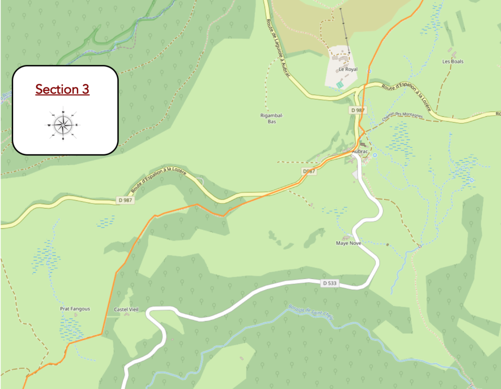
General overview of the difficulties of the route : beyond Aubrac, this is gradually tougher, not always because of the slope, but because of the state of the pathway.

| Aubrac’s gray slate towers quickly appear below. A white Virgin watches over the hamlet. | |
 |
 |
Nearby stands the large building of the Royal Aubrac, witness to past grandeur and which is trying to make a new name for itself. Already in Adalard’s time, the convent of Notre-Dame des Pauvres attracted here not only pilgrims, but also lepers, tuberculosis patients and barefoot people. The story continued long later in the 20th century and Aubrac once again became a place of healing. Gone are the days of sanatoriums, the idea that wisdom is to establish in the crisp, clean air, the scent of the woods, the perfect conditions to perk up aching lungs.
The history of this building is just as mysterious as Aubrac itself. Its conception dates back to 1895, when it was imagined that providing clean air and good milk could benefit people with tuberculosis. In 1902, the building thus became a sanatorium, under the responsibility of Dr Saunal. Later the building became the Royal Hotel, a branch of the Astoria Hotel and International Vichy. The imposing building (over 60 rooms) was one of the most modern of the time, with water, electricity, toilets on each floor. It should be noted that today only 7 inhabitants are registered in the municipality’s register. In the 1960s, it changed assignments, becoming a residence for summer camps and seminars. But that did not last long. For years, the building was abandoned in the harsh winter conditions. A private bought the hotel in 2008. Renovations are underway to transform the building.
Anyway, you can find accommodation here, in an annex of the hotel.

| The pathway crosses the D589, the departmental road that runs through Aubrac and which you have been following for a long time. Just below the road, at the entrance to the hamlet, on a modern work, created by Jean-Claude Lanoix, sculptor from Alsace, you can read: “In silence and solitude, we can only hear the essential”. When you glide the eye in the circle of the work, you can line up the Virgin above and the Dômerie of the village below. | |
 |
 |
| Aubrac is close by, mysterious, austere, magnificent. Aubrac is in fact the heart of the plateau. When the pilgrim enters the village, coming from the east, he first sees the Church of Our Lady of the Poor, its Romanesque arches and its bell tower. Aubrac is as big as a pocket square, with a small lake below the countryside, unfortunately quite far from the village. No one could tell us why the monks did not take advantage of the tranquility of this place to build their monastery a little lower. Anyway, no pilgrim goes there, or so little … | |
 |
 |
| Located at an altitude of 1260 m, the hamlet now includes the remains of the old monastery, a few hotels. In view of the smallness of the place, it is difficult to get a precise idea of the whole that constituted the monastery in the Middle Ages. Some original buildings remain of the monastery. One of these buildings dates from the 12th century; it used to be the hospital, with its beautiful narrow windows. A second building is a large tower 30 meters high, the Tour des Anglais, pierced to the south by six openings. The Chapter Church, the Church of Our Lady of the Poor, Byzantine style is intact. The presbytery, without any particular character, completes the crew. The convent extended over a length of over 100 meters and an equivalent width. It was surrounded by a great wall and included in addition to the buildings still present buildings for the monks, a cloister, a cemetery, an oven, a forge, and prisons. A real village, in a way. The front door was engraved with the inscription “In loco horroris et vastae solitudinis” (in this place of horror and vast solitude). Outside the confines of the convent, an inn and a large stable were available to pilgrims and travelers.
|

A document, dated 1216, tells the origins of the Dômerie d’Aubrac. Around the year 1100, Adalard d’Eyne, son of a Count of Flanders, going to St Jacques de Compostela, would have crossed these rugged forests, where there was only one ancient Roman road. He was assailed by robbers and brigands. Facing the aggressors, he would have vowed to found a hospital in this place and to purge the mountain of highwaymen. He almost died here in a storm when he returned from Santiago, rushed with his mule into the ravine. This new danger would have comforted him in his wish to found a place for the pilgrims, who could find a shelter to fight against the perils of the road (wolves, robbers, extreme climate). Is it a legend or reality? Nobody knows it. Another story tells that on his return from Santiago with his 30 knights, seeking shelter for the night, he fell on a cave. Inside, there were dozens of heads of decapitated pilgrims. He had a vision of the sky to order him to create a refuge for pilgrims in this terrible place. Whether in gratitude for his deliverance or for driving out of his mind the horrible massacre, Adalard founded Aubrac, a hospital monastery around 1120. Thirteen priests were charged with ecclesiastical tasks. A dozen knights were added to protect the pilgrims from the bandits. Lay brothers took care of the sick and ladies of good family management of kitchens and cleanings. « Donats » – people who had given their lives and belonged to the hospital and resided there-, supplemented the staff, managing the lands and forests of the community. They were treated like the brothers of the hospital.
Adalard worked on his project for fifteen years and, when he died in 1135, two bodies of buildings were already built: a hotel for travellers and a house for religious. The monks began deforesting the swampy lands where mostly beeches and oaks grew. Following Adalard, the monks cleared the entire forest, turning it into pasture. Pastures became the wealth and honour of the monastery. The monks enlarged the monastery and the hospital, benefiting from the help of local lords. The Dômerie was under the rule of St Augustine. Knights of the Knights Templar provided protection for pilgrims. Soon, the community began to grow. Half of the properties were around the monastery, the other half in more welcoming places, in the Lot valley and in Cantal. The hospital soon received multiple donations from the lords and clergy of the neighbourhood. For the community, the benefit went even further, since the pope even covered the religious with his protection, recognizing the privilege of relying solely on the Holy See. From 1240, the prior of the building bore the name of Dom (master) and the site was called Dômerie Aubrac. The church and two private buildings remain from the founding era. The Doms succeeded one another over time. The privileges, the hard work and the divine blessing quickly made this place an immense area around the hospital. It took centuries to eradicate much of the surrounding forests to enhance uncultivated and swampy land. But the prosperity of the place also excited the envy of neighbouring communities. Many times, the monastery was besieged and pillaged. In 1348, the religious had erected the Tower of the English, to protect themselves from these « accursed English » which had invaded the neighbouring Rouergue. The tower did not prevent the incursion and looting of the English, all highwaymen who took the torch from the English and Protestants during the Wars of Religion.
With time, the religious showed some signs of looseness in observing their rule. The domain had become so extensive that a new management system had to be put in place. In 1467, the Domerie was built as a commendatory abbey. Revenues of all kinds were divided into three lots. The first batch was allocated to the “Lord Dom ”, the second to the chapter, the third to the management of the community. This measure was at the origin of the decadence of the Domerie. From 1467 to 1790. Aubrac counted 17 abbots, mostly bishops or cardinals. But in those days, these brave ecclesiastics cared more about making ends meet, and sometimes even more, than of watching over the good order and conduct of the community. In 1649, the possessions of the monastery extended over more than 20 parishes of Rouergue and Gévaudan. The corruption became the rule. The monastery was even used to celebrate carnival. The alms of bread, was the hallmark of the institution. Cohorts of peasants from the region numerous here for food. The distribution of bread became scarcer and more chaotic, creating scandalous struggles at the hospital gates. Arrived what was to happen. A royal edict of 1760 suppressed the profit of the revenues of the Domerie. By a decree of 1792, the monastery of Aubrac ceased to exist. The religious were dispersed and the hospital evacuated.
The Dômerie could receive thousands of pilgrims, who, through the cold, the fog or the snow, were guided since very far by the sounds of the bells of the hospice. The bell tower contained the bell called “Maria”, the bell known as the « Bell of the Lost ». It was engraved there: “Deo jubila, clero canta, fuga demones, wanderers revoca ” (honor your God, sing for the loan, chase the demons, recall the misguided ones). It was ringed every night for 2 hours. Nowadays, the administration has installed another bell farther away which sounds half an hour in half an hour, in winter, in foggy weather.
Aubrac has been emptied of its inhabitants by the rigor of its climate and by its geographical position. The original forest has disappeared. Deforestation and the pastoral economy have given this country its current appearance, that of a bare plateau. The wildness of the place disappeared at the same time as the forest. Today, there are only little undergrowth, which has lost all of their unsecure nature. All that remains here is the open sky, the nakedness that opens the way to self-reflection and meditation.
Pliny the Elder reports that the production of what is now called Laguiole cheese goes back to the Antiquity. But it was the monks of Aubrac who selected the cattle breed, developed the techniques of cheese making, and invented “aligot”. It is interesting to note also that the monks developed an agro-pastoral system, based on the complementary nature of the valley and the mountain. They may have been the origin of pastures in the mountains and its corollary, transhumance. The system allowed great autonomy: cereals in the valleys, milk and cheese in summer in the mountains.
| In 1353, a tower 30 m high was added to defend against the brigands, but also against the English of the Hundred Years War. Hence its name “English Tower”. The tower is now a gîte for pilgrims. | |
 |
 |
| Today, Aubrac is no more than a large square in the middle of a crossroads, the Dômerie and a few accommodations around it. It’s been a long time since farm life disappeared from here, even if we try to remember it in another way. | |
 |
 |
The “Tour des Anglais” is a lodging with rather spartan conditions. If the price is derisory (8.5 Euros for the night), the toilets are on the village square. However, the charm is evident. You can, of course, find more comfortable accommodation at the Hôtel de la Domerie, and also in two housing jewels. If you like the baroque, choose the Annexe de l’Aubrac, a rather exceptional cocoon on the village square. If you prefer the stripped-down style, stop by Cyrille at the Colony. The latter has transformed in a rather astounding way an old colony (rooms, apartments on 3 levels and flea market). Whatever your choice, the night will be quiet here.

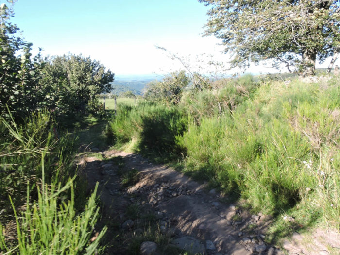
| Beyond Aubrac, there is a sudden transition in the landscape. The route leaves the plateau to plunge quite abruptly into the forest on the foothills of the Lot valley. There is an alternative to the GR65 for people who don’t like steep descents on stony tracks and large stones. Just follow the D533 road, the paved road that slopes straight down to St Chély d’Aubrac. Vehicle traffic is very quiet. The road follows a beautiful valley through which flows the Boralde de Chély, a small river which joins the Lot River, beyond St Chély d´Aubrac to St Come d´Olt. Along the way, 2 km from St Chély d´Aubrac, there is accommodation.
Yet of course, pilgrims will prefer to dive from the barren plains of Aubrac in the tunnels of deciduous trees towards the Lot valley, well below. The lane is very stony. If you like to walk on stones, you will appreciate it because the descent to St Chély d´Aubrac is a real treat. You will quickly understand that in rainy weather it might be better to follow the road. But the pilgrims are thus made. They hate to put their feet outside the paths where they imagine their ancestors suffered blood and water. Yet, there has never been a description of the way around here. When following the traditional GR 65 from Aubrac, it briefly follows D987 road running to Espalion. These are the last upheavals of the Aubrac plateau. Then it leaves the road for a narrow, often stony pathway that winds through hazelnut trees, bushes, broom and hornbeam bushes. |
|
 |
 |
| At the beginning, the pathway runs through meadows amidst wild grasses, rosehips, hazelnuts, hawthorns, rowan trees and blackthorn trees. | |
 |
 |
Gradually, the stony lane approaches the forest.

| The pathway soon begins to slope downhill. Pebbles are still discreet. The trees are increasing in size. They are above all large and majestic ash trees, hornbeams and beeches whose trunks resemble birches, chestnut trees in shambles. Oaks and conifers are more inconspicuous here. | |
 |
 |
| Further down, the pathway leads to a small ledge in the dense forest where the discreet Adrech brook flows. | |
 |
 |
 |
 |
| Shortly after, the route comes out of the undergrowth, arrives on a sort of plateau. | |
 |
 |
Here the landscape opens up to reveal the Lot valley. Even if the vegetation has changed considerably, you are still in Aubrac, as evidenced by the stone walls and barbed wire. You are halfway down, on the last rest of the Aubrac plateau. From one slide to another, the trail is divided into levels. The descent to the Lot River is irremediable, programmed.

Section 4: Slope and pebbles, ask for the program.
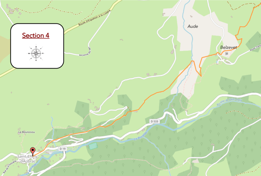
General overview of the difficulties of the route: demanding downhill to Lot Valley, tough not always because of the slope, but mainly because of the condition of the lane.

| At the start, the descent does not promise to be severe along low walls covered with broom and tall grass. | |
 |
 |
But soon, everything changes and the hiker will dive to the bottom of the valley, on large irregular stones as a pathway. Stones, more stones, always stones, of all sizes, on a severe slope marked out by small mossy walls.

| You have to think about where you are going to set foot, right?
Wait for the video to load. |
| On the way down, the gaze falls on the fault where the Boralde de St Chély flows, and higher up on the hill where you’ll have to climb there later. You know in advance, the route will slope up, that’s obvious. | |
 |
 |
| Rare unoccupied stone houses haunt this arid landscape where all is stone and rockery. | |
 |
 |
| Soon, the small hamlet of Belzevet will appear, a small handful of massive houses, with slate roofs that can lie down to the ground. | |
 |
 |
Just below the hamlet, the route runs around the basalt pillars of an ancient volcano. It is a lava chimney released by erosion, such as you find in the town of Le Puy. The miserable ruins of a feudal castle are still present on the summit.

| You might come across another breed of cattle here, the Salers. These cows are quite irresistible, with their mahogany or black dress, their long, corky hairs. With their lyre-shaped horns, these cows are most often found in Cantal. Enthusiastic breeders try to revive the original breed, which is black, and which comes from the bottom of the ages. Apparently brown cows are more inclined to rub shoulders with the many walkers that pass by here. Because, it must also be said. Many hikers climb up the path, coming from St Chély d´Aubrac. The Aubrac trail passes through there. | |
 |
 |
The tracks are steep and stony on this side of Aubrac, wedged between walls and dry-stone walls. They can be muddy, slippery like hell. The landscape is bocage with its rather exuberant vegetation. It is always ash trees, beeches, oaks, maples and chestnuts that slip behind the low walls cluttered with stones. The slope of the pathway then becomes even more severe, through woods and streams to St Chély d’Aubrac.
It is a sort of miller’s lane lined with stones covered with moss, in limestones and shales. Large stones are scattered in abundance on the path. Large roots seep into the rocks. And to think that, in the past, oxcarts used this pathway!

For your pleasure …
Wait for the video to load.
| Yet, there are sometimes moments of respite to relieve his tendons. | |
 |
 |
| But it never lasts very long. | |
 |
 |
| Yet, everything happens. For a moment, the slope really calms down and the pathway flattens in the deciduous trees, where there are many chestnut trees here. | |
 |
 |
 |
 |
But, here again, it does not last very long …
Wait for the video to load.
| A little further down, some traces of civilization probably lost forever. | |
 |
 |
| Further down, the pathway arrives soon near Adret brook, and the route becomes even more difficult. Moreover, a revealing sign advises animal drivers and cyclists to reach St Chély d’Aubrac by road. In rainy weather, do the same. Crossing the stream in the middle of the weeds on an excessive slope will not please many of you. | |
 |
 |
| You have to think about where you are going to set foot, right?
Wait for the video to load. |
| After crossing the stream where it is not the urge to stop at the picnic table that will convince you, you are off the hook. | |
 |
 |
| The difficult and winding track is now over. Sloping down from 1,366 m to 875 m in altitude is a must. The paved road will finish the job to get to the village. | |
 |
 |
 |
 |
St Chély d´Aubrac is a charming little village of 530 inhabitants. Many pilgrims stop here, in a village which is also the starting point for many hiking trails in Aubrac. UNESCO classified the journey from Nasbinals to Chély d’Aubrac in the Heritage of Humanity category in 1998. The same is true of the Pont des Pèlerins (Pilgrim Bridge) and its stone cross. The steep road that led to the bridge over the Boralde was the Rue des Tanneurs. The Pont des Pèlerins is a double arch bridge, built in the Middle Ages.

| The Romanesque church dates from the 11th-12th centuries. It was rebuilt in the 15th century, after a fire during the Hundred Years War. It remains a tower of the old fortifications and a belfry. Inside, you find a copy of a Rubens, and a Gothic bas-relief depicting Christ and four of his apostles. | |
 |
 |
| The village still has a 15th century tower which belonged to the “Chapelains de Cuisinis”. Today the tower is private and has become a very beautiful guest house. Charming village women knit and chat at the foot of the tower. | |
 |
 |
 |
 |
| Here not all loggers and pilgrims are made of flesh. | |
 |
 |
Local gastronomy
In Aubrac, apart from cheese, two drinks have a great reputation. The first is the “Aubrac Tea”, a drink made from Calamint flowers and stems that have a subtle but powerful mint flavour. The plant, which grows most often in the undergrowth of birches, presents various virtues. It can be used as an infusion to stimulate digestion, reduce sore throat or control palpitations and vertigo. It can also be converted into many products, such as perfumes for desserts, sweets, ice creams. But the plant also serves to obtain a liquor, obtained after maceration of the leaves in alcohol. The liqueur can be served as an aperitif or as a digestive.
Another liquor is gentian, obtained from the roots. In Aubrac, the gentian used is yellow gentian. The liquor is not specific to Aubrac. It is present everywhere in the Alps, where the blue gentian is most often used. In Aubrac, gentian is softer, and can be served as an aperitif or as a digestive.
Lodging


 |
 |
 |
 |


 |
 |
 |
 |
 |
 |
 |
 |
 |
 |
Feel free to add comments. This is often how you move up the Google hierarchy, and how more pilgrims will have access to the site.
 |
Next stage : Stage 7: From St Chéy d’Aubrac to St Côme dOlt |
 |
Back to menu |