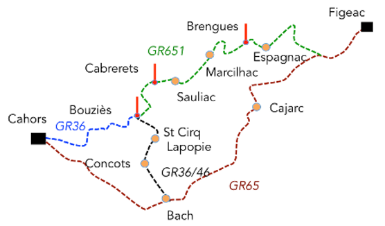
Between Figeac and Cahors, the pilgrim continuing the journey toward Santiago crosses one of the most characteristic landscapes of Quercy. Entering this stretch of the Way of Saint James, the traveler discovers a region defined by limestone plateaus (causses) and deep valleys carved by rivers. Here, several routes allow pilgrims to head west. The best known is the GR65, the traditional Le Puy route. But other itineraries, such as the Célé Valley variant (GR651, then GR36 and GR46), or certain sections of the GR6, offer walkers landscapes and atmospheres that are noticeably different, each providing its own way of experiencing this mineral-rich land. Each of these routes reveals a different face of the Lot region and the Quercy plateaus.
.
The GR65, the traditional route
Leaving Figeac, a medieval town with narrow streets and houses of pale stone, the walker gradually climbs toward the first rises of the causse. The route winds between dry-stone walls, crosses grassy hollows, and runs through woods of downy oaks. The soil becomes lighter, almost white in places. This is the limestone surfacing, the defining stone of the entire region. On these austere yet luminous plateaus, the horizons open wide. Here, the causse sets the rhythm. The eye travels far across a mosaic of sparse fields, thorny bushes, and small hamlets clustered around a church tower. This is the world of the causse, rugged and stripped down, yet possessing a quiet beauty that gradually reveals itself to the attentive walker. Further on, the route descends into the Lot Valley, reaching Cajarc, a village stretched along the river. Here, water brings a new softness: gardens, poplars, and green meadows contrast with the dryness of the plateau. But the pause is brief. As soon as the village is left behind, the route climbs back up onto the causse toward Limogne-en-Quercy, resuming its long passage through open landscapes dominated by silence and stone. Dolines, natural depressions in the karst terrain, appear as small circular clearings where deeper soil allows for some cultivation. In places, stone huts (“cazelles”) emerge along the route, bearing witness to patient rural labor. From there, the walk continues across the Quercy plateaus, through dolines, dry-stone “cazelles”, and scattered villages. Gradually, the relief softens, the Lot Valley widens, and the silhouette of Cahors comes into view within a broad bend of the river.
We will not provide a detailed description of this route here. It is available on the website under the Via Podiensis (Stages 13 to 16, from Figeac to Cahors, via Cajarc, Limogne-en-Quercy, and Vaylats).
The Célé Valley Variant (GR651, then GR36/46)
Here are the stages between Figeac and Cahors son the route of “Variante de la Vallée du Célé”. Click on the stages to open :
Stage 02 : Espagnac to Marcilhac-sur-Célé
Stage 03 : Marcilhac-sur-Célé to Cabrerets
Stage 04 : Cabrerets to St Cirq-Lapopie
Stage 05 : St Cirq-Lapopie to Vaylats
You can either go directly to the stage of your choice or follow the navigation from one step to the next. Have a nice trip.
The variant through the Célé Valley is one of the main alternatives to the main route between Figeac and Cahors on the Way of Saint James. It is now waymarked as a variant of the Le Puy route and follows mainly the GR651, before later joining the GR36 or the GR46 depending on the chosen option to reach Cahors. This route, slightly longer than the GR65 route, crosses one of the most spectacular landscapes in the Lot region, the deeply cut Célé Valley, carved into the limestone plateaus of the Quercy.
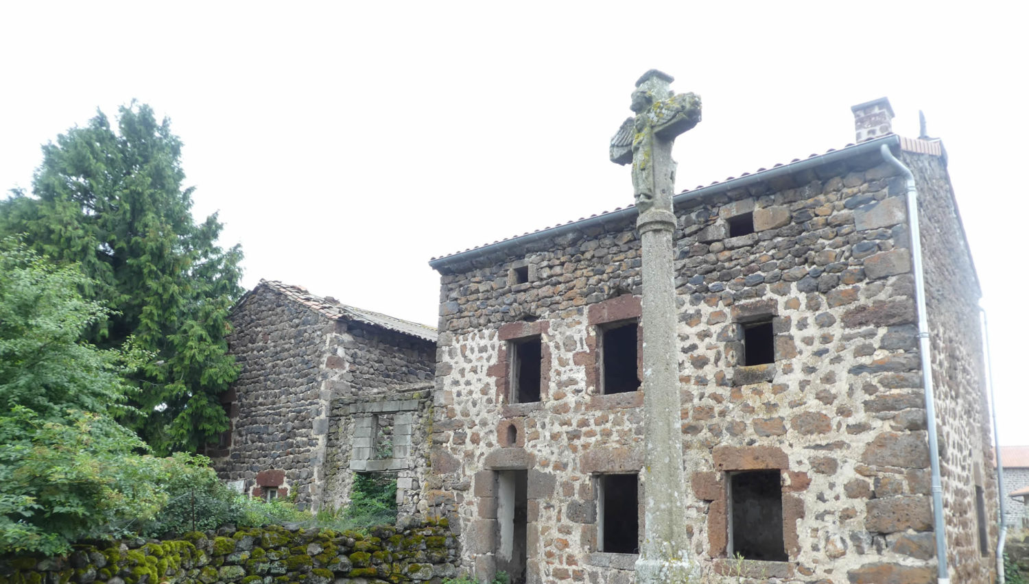
Leaving Figeac, the route first remains identical to that of the GR65. The two routes run together as far as the village of Béduer. There, the Célé Valley route leaves the main route and follows the GR651. Very quickly, the landscape changes in character. The open plateaus of the causse gradually give way to a more enclosed and greener terrain. The walker gradually descends into the Célé Valley, where the river becomes the discreet but constant thread of the journey. After a few kilometers, the first limestone cliffs appear, announcing the true valley. The Célé winds between steep slopes where shaded woods, narrow meadows and rocky ledges alternate. The route then reaches Corn, a small village with an almost medieval atmosphere. Here, stone dominates everything, walls, houses, stairways and terraces. The limestone façades seem to rise directly from the ground, as if the village had grown out of the rock itself. In this part of the valley, grey cliffs sometimes rise directly above the water. Wooded slopes fall toward the river and light filters through the foliage. The route runs alongside the Célé in places, then climbs slightly along the slopes along certain rocky ledges. The walk becomes more varied, alternating between sections by the water and short climbs toward small terraces above the valley. The route then leads to Espagnac Sainte Eulalie, a village closely set against the river. The site is dominated by the former Augustinian priory, founded in the ninth century, whose church and convent buildings recall the spiritual importance of this valley along medieval routes. The whole forms a remarkable harmony, the pale stone of the houses, the calm river and the cliffs that close the horizon. Continuing westward, the valley becomes even more striking. The route runs through Brengues and then reaches St Sulpice. There, some houses seem to be built directly into the cliff. Troglodyte dwellings appear in the limestone walls, carved into the rock over the centuries. The cliffs grow higher and more impressive. Several natural cavities, caves and rock shelters bear witness to very ancient human presence, sometimes dating back to prehistoric times. This section of the route is often considered one of the most demanding in the valley. The stony path follows the contours of the causse, alternating between climbs and descents that can sometimes be steep. The paths leave the river, rise to the plateaus, descend again into the valley floor, then climb once more. This succession of changes in elevation gives the route a dynamic and energetic character. The walker moves through woods, cliffs and limestone clearings, in a landscape of great diversity. Further on appears Marcilhac- sur- Célé, undoubtedly one of the most striking sites in the valley. The village is organized around the monumental ruins of its Benedictine abbey founded in the eleventh century. The high stone arches dominate the rooftops of the village and bear witness to the importance this valley once held in the monastic life of the Quercy. Here, the landscape remains deeply enclosed, the river, the white cliffs and the stone houses forming a harmonious whole. Beyond Marcilhac, the route constantly returns to the relief of the causse. The paths climb onto the plateaus, descend toward the valley, and cross small roads that often end in a dead end at some isolated hamlet. Solitude is common here, with only a few walkers encountered along the way. The route then reaches Cabrerets, another distinctive place in the Célé Valley, where troglodyte houses still cling to the limestone cliffs overlooking the river. The landscape retains this remarkable balance between water, rock and human settlement, which defines the character of the valley.
From Cabrerets, the route leaves for a while the intimacy of the valley and climbs back up onto the causse. The ascent is gradual but steady, and the landscape changes once again. The cliffs fall away behind, the river slowly disappears, and the wide-open spaces of the limestone plateaus return. The route crosses a harsh, almost austere land where vegetation is low and sparse, with stunted oaks, juniper bushes and thorny shrubs clinging to the pale rock. The route runs near the remarkable Pech Merle Cave, one of the major prehistoric sites of the Quercy. In these limestone depths, prehistoric people left paintings and handprints more than twenty thousand years old. The presence of the cave is a reminder that these cliffs and plateaus were inhabited long before the pilgrimage routes. After crossing the causse, the route gradually descends toward the Lot Valley and reaches Bouziès, a village located not far from the confluence of the Célé and the Lot. Here, the pilgrim leaves the GR651 and faces a choice of route. It is possible to reach Cahors directly by following the GR36. However, many will prefer, and rightly so, to make a detour via St Cirq Lapopie by following the GR36 and the GR46. This detour adds an extra day of walking, but it is one of the most memorable parts of the journey. The section leading to St Cirq Lapopie is one of the most distinctive in the region. Leaving Bouziès, the walker follows the old towpath carved into the rock face along the banks of the Lot. This narrow passage, cut directly into the cliff, runs beneath pale stone and limestone overhangs. The river flows quietly below, while the rock face casts a cool shade over the path. In places, the stone is decorated with contemporary plant sculptures that blend into the rock. Gradually, the route approaches St Cirq Lapopie. The village then appears, perched high on a cliff overlooking the Lot Valley. Houses with brown roofs and stone façades seem to cling to the rock face. Narrow streets, old shops and medieval houses give the place a remarkably preserved atmosphere. The village is often listed among the most beautiful in France and was made famous in particular by the writer André Breton, who found refuge and inspiration there. From this spectacular vantage point, the view opens across the entire Lot Valley. The pilgrim knows that only a few kilometers remain before reaching Cahors, yet this stage often marks one of the aesthetic and emotional highlights of the journey between Figeac and Cahors.
From S Cirq Lapopie, the route leaves one of the most spectacular viewpoints over the Lot Valley and gradually returns to the more open spaces of the causse. The route moves steadily away from the river and climbs back toward the limestone plateaus. Very quickly, the atmosphere changes, the cliffs fall behind, and the walk regains the broad, unhurried rhythm of the Quercy landscapes. The route first reaches the higher ground of the causse, where dry grasslands and low oak trees dominate. The stony soils, sometimes whitened by limestone, reflect the light. Here, the landscape stretches widely, marked by dry stone walls, small isolated farms and “cazelles” scattered across sparse fields. This crossing gives the walker the feeling of entering a silent land, almost motionless, where villages appear only after long stretches of walking. The route then reaches Concots, a village set at the heart of the causse. Around the village, farmland is divided into small plots enclosed by stone walls. The landscape retains an austere quality, yet also a sense of harmony, shaped by the long-standing balance between people and this dry land. From Concots, the route continues across the gently undulating plateaus of the Limogne causse, alternating between stony paths, small rural roads and trails lined with shrubs. Further on appears Bach, another typical village of the Quercy. The houses are built from local pale stone, with brown tiled roofs that almost blend into the color of the ground. The walk then continues toward Vaylats. The village is notable for its former hospital and monastic complex, whose church and buildings recall the importance of these places of hospitality along the pilgrimage routes. Around the village, the causse returns to its mineral appearance, with short grass, pale stones and narrow paths bordered by walls that wind between the fields.
At Bach or at Vaylats, the route has rejoined the GR65. The landscape remains true to the spirit of the Quercy, a pale and stony land where fields sometimes seem to emerge from a thin layer of soil resting on limestone. Dry stone walls draw long, low lines across the plots, bearing witness to centuries of patient rural labor. The route winds between sparse meadows and woods of downy oaks, whose short, twisted trunks seem to struggle against wind and drought. The walk is calm but steady. The ground alternates between exposed limestone slabs and earthy paths where a few white stones occasionally roll underfoot. In places, “cazelles” appear in clearings, small dry-stone huts with perfectly formed vaults, once used by shepherds and farmers. These discreet structures recall that these plateaus, now silent, were once intensively worked. Here, the pilgrim walks along the Cami Ferrat, also known as the “Chemin de César.” This ancient way crosses the causse with remarkable straightness, cutting through the landscape without truly passing through villages. This long, solitary progression is one of the great moments of the Way of Saint James, a broad and silent walk where space seems to stretch endlessly. The route alternates between stony trails and small rural roads that serve a few isolated farms. After crossing the motorway, the path quickly regains its quiet character and once again follows the gentle contours of the plateau. It climbs slightly, descends into a combe, then rises again onto a ridge. These undulations give the route an almost musical rhythm. Gradually, the relief begins to soften. The rolling forms of the causse signal the approach of the Lot Valley. The walk becomes more downhill, as if the plateau itself were gently guiding the pilgrim toward the river. The final descent toward Cahors marks a clear change in atmosphere. After the mineral harshness of the causse, the landscape becomes more inhabited, more human. The valley gradually opens, and the meanders of the Lot soon come into view. Then the town appears, set within a wide bend of the river. Brown rooftops cluster around bell towers and old streets. There, the massive towers of the Valentré Bridge rise above the Lot. This medieval stone fortress has marked the passage of travelers and pilgrims for centuries. After the long, silent crossings of the causse, arriving in Cahors carries a sense of solemnity, as if the route, after so many plateaus and stony paths, suddenly returns to the full and living presence of a great town on the Way of Saint James.
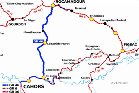
The Rocamadour Variant (GR46 and GR6)
Here are the stages between Cahors and Figeac on the Rocamadour route. Click on the stages to open :
As for us, we made the journey in reverse, from Cahors to Figeac.
Etape 01 : Cajarc à Vers
Etape 02 : Vers à Labastide-Murat
Etape 03 : Labastide-Murat à Rocamadour
Etape 04 : Rocamadour à Gramat
Etape 05 : Gramat à Lacapelle-Marival
Etape 06: Lacaplle-Marival à Figeac
You can either go directly to the stage of your choice or follow the navigation from one step to the next. Have a nice trip.
The Rocamadour variant is one of the major detours of the Way of Saint James between Cahors and Figeac. It leaves the direct line of the GR65 to cross another part of the Quercy. This detour leads the walker to one of the great medieval sanctuaries of Europe, Rocamadour. Pilgrims arriving in Figeac can also follow the GR6 to reach Rocamadour. From there, the GR46 leads walkers toward Cahors.
Leaving Cahors, the route first crosses the Lot River. Gradually, the town fades behind the wide bend of the river. The walk begins gently, still close to the water, along fertile fields, groves and market gardens that occupy the alluvial lands of the valley. The atmosphere remains soft and inhabited, shaped by the presence of water and cultivation. Then the route gradually moves away from the river and begins to rise. The ascent is slow but steady. Little by little, the horizon opens and the landscape changes in nature. The rich soils of the valley fall behind, and the walk reaches the limestone plateaus of the Quercy. The causse reappears with its familiar features, stony ground, dry grasses and small downy oaks clinging to the slopes. The route then alternates between stony trails and small rural roads serving a few isolated farms or scattered hamlets. Space widens; the landscape becomes more austere and more silent. After this gradual climb, the route descends for a while toward the valley and reaches Vers, a small village set along the Lot, nestled between the river and the limestone cliffs. Between Vers and Labastide Murat, the route then crosses one of the most characteristic landscapes of the Causses du Quercy Regional Natural Park. This section marks a clear transition, as the valley is left behind for good and the walker reaches the wide limestone plateaus of the Gramat causse. Leaving Vers, the route climbs quickly above the valley. The ascent is noticeable but remains steady. Very soon, the walker leaves behind the banks of the Lot and the cultivated slopes, entering a wilder landscape. The route climbs through woodland and rocky ground, then opens onto the first flat expanses of the causse. The light becomes sharper, almost harsh, reflected by the white stone that appears everywhere. The walk continues through a typical karst landscape, with narrow combes, grassy dolines and small stony plateaus dotted with oak trees. Dry stone walls draw long irregular lines across the sparse fields. In places, cazelles appear, small shepherd huts built in dry stone, their perfectly fitted vaults bearing witness to an ancient craft. The route crosses vast, almost deserted spaces. Villages are rare and often hidden behind folds in the terrain. Silence dominates. Over the kilometers, the route gently rises and falls across the causse. The climbs and descents remain moderate but regular, giving the walker the feeling of moving across a frozen sea of stone. Vegetation remains sparse. As Labastide Murat approaches, the landscape becomes slightly more inhabited. Cultivated plots appear more frequently and roads converge toward the village. It occupies a central position on the Gramat causse, once a crossroads of roads and routes. Its pale stone houses, its church and its open squares contrast with the vast silent spaces the walker has just crossed. The place also holds a singular page of history. Labastide Murat is the birthplace of Joachim Murat, a marshal of Napoleon who became King of Naples at the beginning of the nineteenth century. Thus, in the heart of these austere plateaus of the Quercy, the route suddenly encounters the shadow of a destiny that led one of its native sons to the thrones of Europe.
From Labastide Murat, the route continues across the Gramat causse toward Rocamadour. This stage crosses one of the most characteristic landscapes of the Causses du Quercy, a vast limestone plateau, austere in appearance, yet rich in detail for the attentive walker. Leaving Labastide Murat, the route quickly leaves behind the last houses of the village and returns to the open expanses of the causse. The landscape stretches in broad, stony undulations where downy oaks and dry grasses still dominate. The soils are pale, sometimes almost white, and the light reflects strongly from them. The route continues to alternate between stony paths and small rural roads that serve a few isolated farms or rare hamlets. The walk unfolds once again in a typical karst landscape, across a poor and untamed plateau. Wooded combes occasionally cut into the terrain. Dry stone walls, ever present, mark out the fields and bear witness to the patient work of generations of farmers who shaped this austere land. The route passes through several discreet hamlets such as Couzou and Montfaucon, villages of pale stone that seem to rise directly from the limestone. The houses are low, covered with brown tiles, clustered around a church or a small square. As the kilometers pass, the landscape remains widely open. The walk is steady, almost meditative, guided by the gentle undulations of the causse. Then, gradually, the terrain changes. The plateau suddenly breaks off and the land seems to tear open. The walker approaches the canyon of the Alzou. The route then leaves the open spaces of the causse and descends into a deep, wooded and shaded valley. Limestone cliffs appear, high and steep, and vegetation becomes denser. The descent is pronounced and leads gradually toward Rocamadour. The village then appears in a spectacular way, clinging to the cliff above the Alzou Valley. Houses seem stacked against the rock face, dominated by the sanctuary and its chapels. For centuries, this site has attracted pilgrims and travelers who come to venerate the Black Madonna of the sanctuary. Arriving in Rocamadour is often one of the most striking moments of this route. After the long, silent crossing of the causse plateaus, the sudden sight of this town suspended in the rock gives the journey an almost unreal dimension. Rocamadour remains one of the great destinations of tourism in France, and rightly so.
Leaving Rocamadour, the walker first enters one of the most distinctive landscapes of the Quercy, the Alzou Valley. This small river, now often discreet or intermittent, has nevertheless carved a deep gorge over thousands of years into the limestone of the Causses du Quercy. As soon as one leaves the terraces of the sanctuary, the route descends into this narrow and wild valley where nature quickly reclaims its place. The contrast is striking. Behind you, the suspended town of Rocamadour still draws visitors, yet only a few hundred meters further on, silence settles in. The valley narrows between steep limestone cliffs, often covered with oaks and shrubs. The light becomes softer, filtered through the vegetation. The humidity of the valley floor supports a denser plant life than on the causse plateaus, with moss, ferns and shaded undergrowth accompanying the walk. This gorge was once far more active than it is today. The Alzou powered several mills, whose ruins still line the valley. The walker gradually discovers the remains of these hydraulic structures, set along the river or hidden within the vegetation. Among the best known is the Saut mill. These stone buildings, sometimes half overtaken by trees, bear witness to a milling activity that was once essential for the villages of the causse. Today, the whole has an almost mysterious character. Collapsed walls, stone arches and old water channels appear among roots and brush. One can easily imagine the time when these mills used the force of the river to grind grain brought from the surrounding plateaus. The valley must then have echoed with the sound of water and the work of the millers. The route follows the valley floor for a time, running alongside the river or crossing small rocky sections. In places, the trail slips between cliffs and trees, giving the setting an almost secret atmosphere. This section of the route is often considered one of the wildest in the Rocamadour area. Gradually, however, the valley opens out and the route begins to climb back toward the plateaus. The ascent leads the walker out of the Alzou gorge. The woodland becomes lighter, the cliffs fall behind, and the clear light and open horizons of the causse return, leading toward Gramat. Arriving in this small town marks a transition. After the wild spaces of the causse and the spectacular relief around Rocamadour, Gramat appears as a lively center of the Gramat causse. Its streets, shops and pale stone houses contrast with the vast plateaus the walker has just crossed.
Leaving Gramat, the walker heads east toward Lacapelle Marival, still following the GR6. The exit from the small town is quick, a few still lively streets, then the route immediately returns to the open expanses of the Gramat causse, with its typical, rugged and untamed character. Most often, the rare cultivated plots are bordered by long dry-stone walls, and sparse meadows alternate with small oak woods. Near Issendolus, the area becomes slightly more inhabited. Even though the causse remains ever present, the landscape now feels more open. The route continues to alternate between stony paths and small rural roads. Further on, the walker reaches Thémines. The village spreads at the foot of a shallow depression in the terrain, surrounded by meadows and fields. The houses are built from the local pale limestone and grouped around the church and a few narrow streets. The landscape is already beginning to change. The soils become deeper, the meadows greener and hedgerows more frequent. Beyond Thémines, the route runs through several hamlets and farms. The transition between the causse and the Limargue becomes increasingly noticeable. The stony plateaus soften, woodland becomes denser and pastures widen. The walker gradually leaves the mineral world of the causse and enters a more fertile region. The route then approaches Rueyres. The village appears among the meadows, with houses grouped around the church and a few farms scattered nearby. Here, agriculture is more present, with fields, pastures and hedgerows shaping a gentler landscape than that of the plateau. Finally, the route reaches Lacapelle Marival. The arrival is marked by the imposing silhouette of its medieval castle. Its high stone towers dominate the village and recall the historical importance of the place in the Middle Ages. After the silent expanses of the causse and the gradual transition toward the Limargue, Lacapelle Marival offers the walker a lively and welcoming stop before continuing the route toward Figeac.
Leaving Lacapelle Marival, the route continues east toward Figeac. The walker remains on the GR6, entering a region that marks the transition between the limestone plateaus of the causse and the gentler landscapes of the Limargue and the Ségala, characteristic of the Lot region. As the village is left behind, the landscape already begins to change in tone. The wide stony expanses of the causse give way to deeper and more fertile soils. Meadows become more frequent, hedgerows line the paths and trees grow taller. The walk unfolds among fields, groves and small green valleys where water reappears in the form of streams and springs. Midway along the route lies Cardaillac, one of the most remarkable villages in the area. The medieval village clings to a hillside and retains a very ancient character. Three tall towers still rise above the houses clustered along narrow streets. The whole has a preserved atmosphere, almost outside of time. From the heights of the village, the view stretches across wooded hills and meadows that already announce the Célé Valley. Continuing onward, the route passes through several hamlets and farms scattered across the countryside. The landscape becomes more undulating. Fields alternate with woodland and pastures where herds graze. Dry stone walls, still present, sometimes give way to hedgerows and embankments more typical of the agricultural lands of the Limargue. Farms are surrounded by meadows and orchards, and the paths wind between cultivated fields and woods. As Figeac draws nearer, the terrain becomes more pronounced. Hills follow one another and valleys deepen. The walk alternates between gentle climbs and descents, giving the landscape a more dynamic character. Vegetation becomes denser and the presence of the Célé Valley is increasingly felt. Finally, the route reaches the heights overlooking Figeac. The town gradually appears at the bottom of the valley, recognisable by its clustered rooftops and bell towers. After the quiet villages and green countryside of the Limargue, arriving in Figeac offers a marked contrast, a lively medieval town rich in history, whose narrow streets and stone houses recall the importance it once held in trade and along the pilgrimage routes.